How to handle the Distillery District's Cobblestone Streets and Heritage Alleys

The Distillery District's cobblestone streets and heritage alleys present unique navigation challenges that can trip up even regular visitors. This guide maps the most efficient routes through the historic district, flags pedestrian-only zones, and explains accessibility considerations that'll save time. Whether heading to a gallery opening on Trinity Street or meeting friends near Tank House Lane, understanding how to move through this preserved 19th-century complex makes every visit smoother.
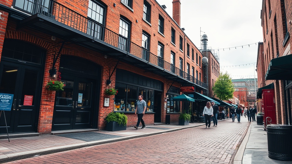
The limestone pavers and compact Victorian industrial layout require different navigation strategies than typical Toronto neighborhoods. Here's the thing—the same alleys that feel spacious on a Tuesday morning become impassable on a Saturday evening in December. This post details key thoroughfares and hidden passages, explains where vehicles can and cannot go, and reveals the shortcuts locals rely on. Learn the parking access points, which alleys provide fastest connections between sites, and how to sidestep bottlenecks during events and peak hours.
What's the most efficient route through the Distillery District on foot?
Walking from the Parliament Street entrance at the southern end puts you at the district's busiest intersection—most locals skip this bottleneck entirely. Instead, enter via the less-trafficked eastern access near Cherry Street and Mill Street, then follow Pure Spirit Lane north toward the central courtyard. This route avoids the tourist congestion that clusters around the Trinity Street archway.
From the central courtyard (the plaza between the Archeo Trattoria building and the old Boiler House), three main paths branch outward. Head west on Case Goods Lane to reach the western galleries and the Elm Street connector. Travel north along Tank House Lane to access the northern event spaces and the courtyard behind the Stone Distillery building. Or walk south on Trinity Street toward the district's southern boundary and the Archeo Lane passage.
The most efficient loop starts at the Cherry Street entrance, follows Pure Spirit Lane north to Tank House Lane, turns west past the Fermenting Cellar, then south along Trinity Street, completing the circuit via Archeo Lane back to the starting point. This circular route covers all major areas without backtracking—roughly 800 meters of walking that hits every significant zone.
The catch? This loop assumes you're visiting during standard hours. Morning delivery windows (7-10 AM weekdays) see service vehicles throughout Pure Spirit Lane, forcing pedestrians to squeeze against building walls. The Brick Street connector—often overlooked—provides a covered walkway between the main courtyard and the southern galleries, useful during weather events.
Where can vehicles actually drive within the Distillery District?
Vehicles have extremely limited access here. Only service vehicles, emergency services, and permitted delivery trucks may enter the cobblestone zone. The general public cannot drive through the Distillery District's core pedestrian precinct—this isn't negotiable or dependent on time of day.
For those requiring drop-off access near specific buildings, temporary permits are available through the district management office for accessibility needs. The designated vehicle entry point sits at the eastern edge near the intersection of Cherry Street and Distillery Lane. From there, drivers can access the internal service road that runs behind the main buildings—though this route requires advance coordination.
Parking options surround rather than penetrate the district. The Green P lot at 17 Parliament Street sits one block south. The Distillery District's own parking facility operates at 15 Case Goods Lane, accessible via a separate entrance off Cherry Street. Street parking exists on Mill Street and surrounding blocks, though spaces fill quickly during events. The TTC's 121 Esplanade-River route stops at the district's southern edge, while the 65 Parliament bus connects from the north.
Worth noting: the 15 Case Goods Lane facility fills by 11 AM on weekends. Locals often park in the Canary District's lots to the north and walk south through the less congested northern entrance. This approach adds five minutes of walking but eliminates the frustration of circling for limited spaces near the main gates.
Which streets and alleys should you prioritize for accessibility?
The cobblestone surface creates genuine barriers for mobility devices, strollers, and anyone with balance concerns. Not all paths are equal—some sections have been partially leveled or feature compacted gravel alternatives alongside the historic stone.
| Path Name | Surface Type | Grade | Width | Accessibility Notes |
|---|---|---|---|---|
| Trinity Street (main) | Original limestone pavers | Flat | 4.5m | Uneven stones; wheelchair users report difficulty |
| Tank House Lane | Mixed pavers + concrete | Gentle slope | 5m | Smoother sections near the courtyard |
| Case Goods Lane | Refurbished cobblestone | Flat | 4m | Most level surface in the district |
| Pure Spirit Lane | Original cobblestone | Slight incline | 3.5m | Narrow; service vehicles occasionally pass |
| Archeo Lane | Compacted gravel path | Flat | 3m | Best alternative for strollers/mobility devices |
| Distillery Lane (service) | Asphalt | Flat | 6m | Restricted access; smoothest surface available |
The limestone pavers on Trinity Street retain their 19th-century irregularity—charming visually, but genuinely challenging underfoot. For those using wheelchairs or walkers, Case Goods Lane offers the most reliable surface, followed by the compacted gravel of Archeo Lane. Tank House Lane's western section (near the Boiler House) was partially restored in 2019, making it more navigable than the eastern stretch.
Avoid Pure Spirit Lane during morning delivery hours (7-10 AM weekdays). Service vehicles need that narrow passage, and the cobblestones get slick from condensation overnight. The heritage preservation status that protects the Distillery District's character also prevents modern accessibility modifications to the street surfaces—this creates genuine barriers that require workarounds and advance planning.
The gradient changes throughout the district are subtle but meaningful. The slope from Tank House Lane down to Trinity Street represents the most significant elevation change, and the cobblestone surface makes this descent particularly challenging when wet. Several buildings maintain secondary entrances at the rear that avoid these grade changes entirely—the Archeo Trattoria's Distillery Lane entrance provides level access that bypasses the front steps. The district management office maintains current information about accessible routes and can provide maps showing the smoothest paths between specific destinations.
How do you handle the Distillery District during special events and peak times?
The compact nature that makes the Distillery District charming also creates serious congestion during the Christmas Market, art fairs, and summer festivals. The same alleys that feel spacious on a Tuesday morning become impassable on a Saturday evening in December.
The main Trinity Street corridor transforms into a one-way pedestrian flow during major events, typically running southbound only. Security staff direct this traffic at the Tank House Lane intersection. Locals know to avoid the central courtyard entirely during these periods—the density there becomes unmanageable. The shortcut through the Archeo Lane passage to the eastern galleries bypasses the worst bottlenecks, cutting across the flow rather than fighting through it.
For the Christmas Market specifically, enter via the northern access near the former Canary Restaurant building rather than the southern Trinity Street arch. This approach puts you at the market's less crowded end. The Fermenting Cellar hosts indoor events that create spillover crowds—if it's on the calendar, expect Tank House Lane to move slowly between 6-9 PM.
Rain transforms the navigation equation entirely. The cobblestones become genuinely hazardous when wet, particularly the original limestone on Trinity Street and Pure Spirit Lane. During precipitation, prioritize Case Goods Lane and the covered Brick Street walkway. The galleries and shops provide cut-through passages that aren't officially marked but are tolerated during weather—ask any shopkeeper about indoor routes.
Seasonal patterns matter too. Winter brings ice accumulation on the limestone pavers (the Distillery District doesn't salt the heritage surfaces) and reduced visibility in the narrow alleys. Summer introduces evening event traffic that peaks at sunset. The eastern galleries along Case Goods Lane connect through interior courtyards that most visitors never discover—these covered passages become key alternatives when weather turns.
The Distillery District rewards those who slow down. These streets weren't designed for efficiency—they were built for moving goods between Victorian industrial buildings. That legacy means accepting a slower pace and planning extra time, especially when the stones are slick or the crowds thick. Wear appropriate footwear (the gaps between cobblestones catch heels), watch for uneven surfaces, and build buffer time into your schedule. Locals don't rush here; neither should you.
Steps
- 1
Choose the Right Footwear for Cobblestone Walking
- 2
Plan Your Route Using the Main Thoroughfares
- 3
Navigate Accessibility-Friendly Paths and Entrances